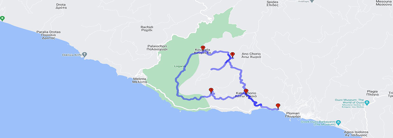
Plomari - Kato Chorio - Levra - Logaras - Kournela - Agatheri - Kato Chorio – Plomari

| General description: |
Circular hiking trail in the southern routes of Plomari. |
| Detail description: |
Agatheri is one of the highest coastal hills in southern Lesvos (625 m.). Olive groves and small settlements have developed on its slopes, which are shrinking today. The topsoil is covered with oak trees. The route starts from Plomari and after a short walk on the asphalt road that leads to Melinta, it begins to climb towards Kato Chorio. Moving west, it meets Leura, crosses the "ridge" of the Logaras area, with an unrestricted view of the southern coasts, Melinta and the sea, and turns north towards the "eagle's nest" of Kournela. It is a semi-abandoned but interesting and cool village. The old olive press, the local architecture, the springs, the large plane tree, and the view towards Paleochori impress visitors. The continuation of the route is an uphill walk towards the chapel of Agia Irini and, descending through the olive groves, it ends up at Kato Chorio, completing the circle. |
| Transportation means: |
Car and bus to Plomari |
| Accessibility: |
Asphalted access to Plomari |
| Best season: |
Winter, Spring, Autumn |
| Places to visit: |
Plomari, ouzo museum, soap-making museum. |
| Signage: |
Yes |
| Route starting point: |
Plomari |
| End of Route: |
Plomari |
| Type of tourism: |
Walk/hike, Nature-loving, cultural |
Points of interest
Plomari
| Name: |
Plomari |
| Description: |
Settlement |
| Category: |
Cultural element |
| Longitude: |
38,975074 |
| Latitude: |
26,368332 |
| Altitude: |
55 |
Plomari was built in its current location around 1842 when the fear of pirates subsided. At the center of the settlement is the church of Saint Nicholas, built in 1847. The town's emblematic symbol is the plane tree in the central square, which is said to have been planted in 1813. It is renowned as the birthplace of ouzo and soap. It stands out for its architecture and masonry, as well as for the many old industrial buildings (olive presses, soap factories, tanneries, etc.).
Kato Chorio
| Name: |
Kato Chorio |
| Description: |
Abandoned settlements |
| Category: |
Cultural element |
| Longitude: |
38,982308 |
| Latitude: |
26,351697 |
| Altitude: |
153 |
The Kato Chorio (Lower Village) is one of the oldest villages in the area. Until the middle of the century, it had many inhabitants. A characteristic example is that there were 9 cafes. The few houses that have remained stand almost lost among the olive trees, orange trees, and lemon trees. To the north of the village is the church of Agios Andreas, a very beautiful and old church. It is worth visiting and seeing the back part of the Holy Step built with carved stones. Following the road to the left of the square (as you come from Plomari), you will find yourself in the Vigla area (observatory), with the chapel of Zoodochos Pigi. Alternatively, if you go straight, you will come across a picturesque square with the plane tree and the fountain of Kato Chorio. The view of the Aegean Sea and the Church of Agios Andreas is amazing. The first thing a visitor sees is the old red cafe.
Levra
| Name: |
Levra |
| Description: |
Abandoned settlements |
| Category: |
Cultural element |
| Longitude: |
38,996137 |
| Latitude: |
26,353119 |
| Altitude: |
430 |
Abandoned rural settlement on the slope of Agkatheri. In the center of the settlement there is the chapel of Agios Ioannis Loutroupiou. The spot is suitable for a stop. The settlement's fountain runs drinking water.
Kournela
| Name: |
Kournela |
| Description: |
Abandoned settlements |
| Category: |
Cultural element |
| Longitude: |
38,997711 |
| Latitude: |
26,336347 |
| Altitude: |
363 |
A small village that offers visitors a world of unparalleled tranquility and natural beauty. Its name comes from the abundant water that existed and indicates the flow of water through the traditional channels. Hidden in the embrace of a mountainous massif, it suddenly emerges before the eyes of the visitor, with the simple figures of its small stone buildings standing out in the vast green of the area. At the entrance of the village, the triple-aisled basilica of Agios Ioannis Prodromos dominates, dating back to 1863. Descending the narrow alleys that once teemed with life and gazing across at Paleochori and Melinta, an imposing centuries-old plane tree stands before us. One hundred and fifty meters south of the last house, we will encounter the village's three springs. The visitor should also see the old olive press, which operated until 1963, as the main occupation was olive harvesting.
Agatheri
| Name: |
Agatheri |
| Description: |
Abandoned settlements |
| Category: |
Cultural element |
| Longitude: |
38,995528 |
| Latitude: |
26,346175 |
| Altitude: |
570 |
Abandoned rural settlement, on the slope of a hill. Here are located the chapels of Agia Eirini and the Transfiguration of the Savior. The top of the hill is covered by a forest of rough pine trees. Nevertheless, the location provides the opportunity for a view towards Plomari and the Aegean Sea.
The route
