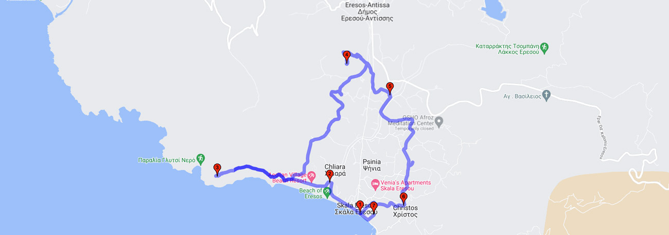
Skala Eresou - Afentelli - (Profitis Ilias Thalassinos) - Profitis Ilias Chorianos -Agia Anna - Psinia - Christos - Vigla - Skala Eresou

| General description: |
Hiking trail that starts from Skala Eressos and passes through the plain among cultivated olive groves, agricultural fields with grasslands, riverbank vegetation and reed beds. |
| Detail description: |
The route crosses the residential areas of the ancient Eresians, the core of Eresos, homeland of the poet Sappho and the naturalist Theophrastus, a student of the great Aristotle. Starting from Skala on the western side of the beach, where the ruins of the Monastery of Afenteli are located. The ascent to the two chapels rewards the hiker with breathtaking views. Every step hides a revelation, in the hard rock or in the plain. Continuing this clockwise circle, it ascends to the top of the ancient acropolis with its two medieval towers and cistern. The acropolis "Vigla or Mastos", very close to Skala and the sea, is crossed and surrounded by paths in every direction. The journey continues eastward and crosses the plain of Eresos, encountering various chapels. About halfway, the route changes direction towards the west and meets the two "Prophets Elijah" the village one and finally the Thalassino one. From Thalassinos Prophet Elijah, the route moves south and along the coast towards the settlement of Skala Eresou, encountering the Psaropotamos. |
| Detail description: |
Car and bus to Skala Eresou |
| Accessibility: |
Paved access to Skala Eressos, Panagiouda, connected to rural roads |
| Best season: |
Spring, Autumn |
| Places to visit: |
The archaeological collection of Skala Eressos, Profitis Ilias, Vigla. |
| Signage: |
Yes |
| Route starting point: |
Skala Eresou |
| End of Route: |
Skala Eresou |
| Type of tourism: |
Nature-loving, walking/hiking, historical |
Points of interest
Skala Eresou
| Name: |
Skala Eresou |
| Description: |
Settlement |
| Category: |
Cultural elements |
| Longitude: |
39.135842 |
| Latitude: |
25.931109 |
| Altitude: |
2 |
The village of Skala Eressos or Gyali is one of the most important tourist destinations in Lesbos. On the left side, to the southeast, there is the pine-covered hill of Mastos (Ochiro-Vigla), where the ancient acropolis and the small harbor with the chapel of Panagouda were located. To the right is "Afenteli" and on the high rock is the chapel of Prophet Elias. On the western side is Psaropotamos, the estuary of the river Chalandra. In the area, there is an archaeological museum since 1962 with unique Archaic, Classical, and Hellenistic findings. In the same area, there is the Holy Tomb and the sarcophagus with the remains of Saint Andrew of Jerusalem, the Archbishop of Crete.
Vigla
| Name: |
Vigla |
| Description: |
Ancient ruins |
| Category: |
Cultural elements |
| Longitude: |
39.134231 |
| Latitude: |
25.934753 |
| Υψόμετρο: |
120 |
The installation on the hill is attested from ancient times up to the early Christian era and includes sections of the walls of the ancient city, a Roman building with hypocausts, and remains of houses.
Christos
| Name: |
Christos |
| Description: |
Church/Monastery |
| Category: |
Cultural elements |
| Longitude: |
39.134701 |
| Latitude: |
25.941243 |
| Υψόμετρο: |
22 |
A picturesque chapel with a beautiful view towards the plain of Eresos, offering a tree-planted cool space for a stop and relaxation.
Agia Anna
| Name: |
Agia Anna |
| Description: |
Church/Monastery |
| Category: |
Cultural elements |
| Longitude: |
39.153225 |
| Latitude: |
25.938016 |
| Υψόμετρο: |
19 |
A picturesque chapel with a beautiful view towards the plain of Eressos and the riverbed of Chalandra, offering a shaded and cool space for a break and relaxation.
Profitis Ilias Chorianos
| Name: |
Profitis Ilias Chorianos |
| Description: |
Church/Monastery |
| Category: |
Viewpoint |
| Longitude: |
39.140547 |
| Latitude: |
25.902534 |
| Υψόμετρο: |
157 |
A picturesque chapel with a beautiful view towards the plain of Eresos
Profitis Ilias Thalassinos
| Name: |
Profitis Ilias Thalassinos |
| Description: |
Church/Monastery |
| Category: |
Viewpoint |
| Longitude: |
39.158256 |
| Latitude: |
25.929103 |
| Υψόμετρο: |
157 |
The panoramic view offers us the possibility to gaze south at the entire coastline of Eresos, north at the small beaches towards Sigri, and east at the plain of Eresos. Finally, we can rest on the steps of the church and pray at the temple.
Psaropotamos
| Name: |
Psaropotamos |
| Description: |
Natural landscape |
| Category: |
Natural landscape |
| Longitude: |
39.13929 |
| Latitude: |
25.925514 |
| Υψόμετρο: |
2 |
The estuary of the X. Chaladras (Psaropotamos) is an important wetland for western Lesvos, hosting turtles, eels, and cephalopods, and serving as a stopping point for feeding for many water birds. Several nests of small aquatic birds can also be observed on the densely vegetated banks.
The route
